01
Cherries
Pale blossom ties the levee into one long line, turning the riverbank itself into a spring corridor.
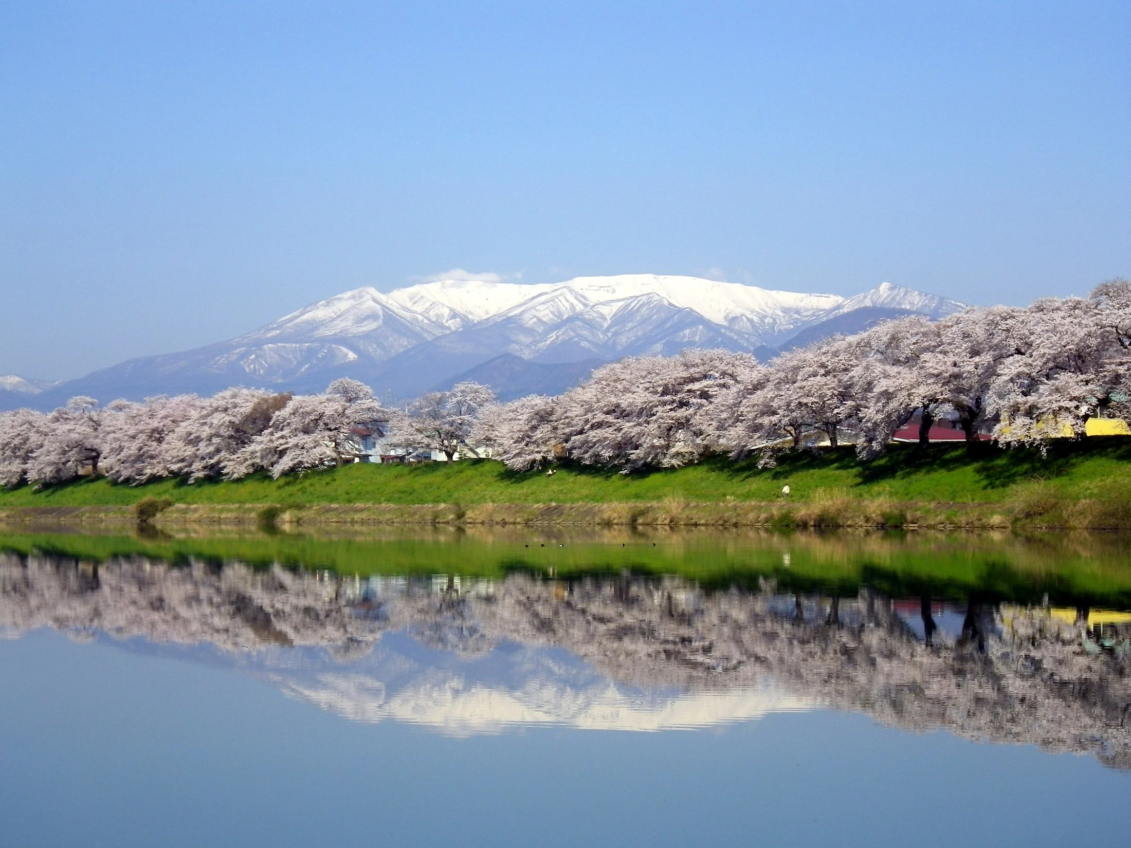
A pink levee, the blue Shiroishi River, snow still on Mount Zao.
Hitome Senbonzakura is not one famous tree. It is a spring landscape that keeps unfolding the further you walk.
Welcome to Hitome Senbonzakura (白石川堤 一目千本桜). “Hitome Senbonzakura” is the name given to the cherry rows running along the levee of the Shiroishi River through Shibata and Ogawara in Shibata District, Miyagi — the first place most spring visitors to Miyagi put on their itinerary. From the top of the levee you can take in a thousand cherry trees at a single glance, which is how the name came about.
This site (hitomesenbonzakura.com) is an independent, unofficial visitor guide that gathers the bloom timing, access, walking routes and nearby spots of Hitome Senbonzakura onto a single page.
Cherries alone do not decide the impression. Putting the river and the far mountains in one frame is what creates the depth you rarely meet anywhere else.
Pale blossom ties the levee into one long line, turning the riverbank itself into a spring corridor.
Blue water sits close to the branches; on still days flowers and the mountain ridge fold together on the surface.
The snow-streaked Zao range enters as distant scenery, so blossom pink, river blue and snow white share a single frame.
So you can decide first thing whether you need an umbrella or an extra layer: current conditions and the seven-day forecast for Hitome Senbonzakura. Wind runs along the levee, so it often feels colder here than in town.
Hitome Senbonzakura is not only a spring place. Snowmelt raising the river, the rainy season and evening squalls, autumn colour, winter waterbirds and snow on the peaks — the makeup of the view changes with each season. The table below sorts weather, water and wildlife tendencies by season.
| Season | Weather (normals) | The water | Nature notes | What to wear | Crowds and timing |
|---|---|---|---|---|---|
| Spring (Mar–May) | Mean temperature 5.5→15.6 °C / monthly rainfall 74–110 mm / monthly sunshine 179–194 h | Snowmelt from Mount Zao raises the flow and makes it cloudy. A still early morning is your chance at a mirror surface. | Somei-Yoshino in bloom (early to mid April, typically). White-eyes and brown-eared bulbuls visiting the blossom; rapeseed on the levee. | A wind shell for cold mornings and evenings. Comfortable shoes and sun protection. | The busiest time of year. Weekdays and mornings are easiest to walk. |
| Summer (Jun–Aug) | Mean temperature 19.2→24.4 °C / monthly rainfall 144–178 mm / humidity 79–83% | The rainy-season front and evening squalls can raise the level suddenly. Do not enter the riverbed; check the signage. | Fresh green and hydrangeas, a breeze off the river, cooler evenings. Waterbirds are busy too. | Hat, drinks, insect repellent. Guard against heatstroke above all. | A quiet season for walking. Early morning and evening are comfortable. |
| Autumn (Sep–Nov) | Mean temperature 21.2→9.8 °C / monthly rainfall 193→59 mm / monthly sunshine 128–147 h | The autumn rain front and typhoons raise the river. Unsurfaced stretches of the levee turn muddy after rain. | Cherry foliage and leaf fall, Shibata’s chrysanthemum doll display, harvest-season kagura dance. | A layer, rain gear and shoes with grip. Sunset comes early. | Not crowded. The raking light of morning and evening suits landscape shots. |
| Winter (Dec–Feb) | Mean temperature 4.5→2.0 °C / snowfall 9–21 cm / deepest snow cover 6–10 cm | Mist can rise off the river on cold mornings. Watch for ice and frost heave. | Swans and other waterbirds on the Shiroishi, snow on the Zao peaks, winter illumination (held in some years). | Warm clothing, gloves and grip. Days are short, so keep the route brief. | Calm walking. Pairs well with the hot-spring towns nearby. |
Southern Miyagi has a Pacific-side climate, with most rain falling in the rainy season (June–July) and the autumn rain and typhoon season (September). April, when the cherries open, is among the sunniest months of the year here (192 hours on average), so the odds of seeing the blossom under clear skies are good.
The Shiroishi is a class-A river rising on the southern slopes of the Zao range, a tributary of the Abukuma system. In spring, snowmelt across the catchment raises the flow and clouds the water. Check the signage before going onto the riverbed or down to the water, and never go down when the river is high.
In spring more small birds come to the blossom; from early summer into autumn waterbirds and insects are active. In winter swans arriving from the north sometimes spend the season on the water, one of the classic sights of the cold months.
Source: Japan Meteorological Agency, past weather data search, normals (Sendai, 1991–2020 average). Sendai, about 40 km north of this spot, is the nearest official observation point; actual values vary with elevation and terrain. Bloom timing, water level and wildlife all change from year to year.
Peak viewing usually falls between early and mid April, but flowering shifts with the temperature of that year. This site does not publish its own forecast, so please confirm the current bloom and festival details with the official sources listed below shortly before you set off.
Rather than walking out and back, use the two JR Tohoku Main Line stations and walk it as a line — the scale of the place becomes much easier to read.
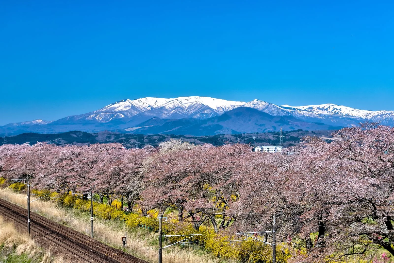
About a 3-minute walk from the station to the Shiroishi levee. Take in the width of the river and the length of the rows first.
About a 20-minute walk from Ogawara Station. A classic viewpoint where water, blossom and Mount Zao stack easily into one frame.
Do not hurry; shift your eye level between the riverbed and the top of the levee. In places you can see trains through the branches.
Leave via Funaoka Station, or, with time and energy, climb to Funaoka Castle Park for a view down over the riverside cherries.
Flowering shifts year to year. Petal storms and carpets of fallen blossom are as much a draw as full bloom.
Easier to find quiet hours, and low light gives flowers and water more depth.
Two to three hours for the riverbank alone; allow half a day with Funaoka Castle Park and a meal.
Seasonal sightseeing boats, the slope car and temporary car parks may charge a fee.
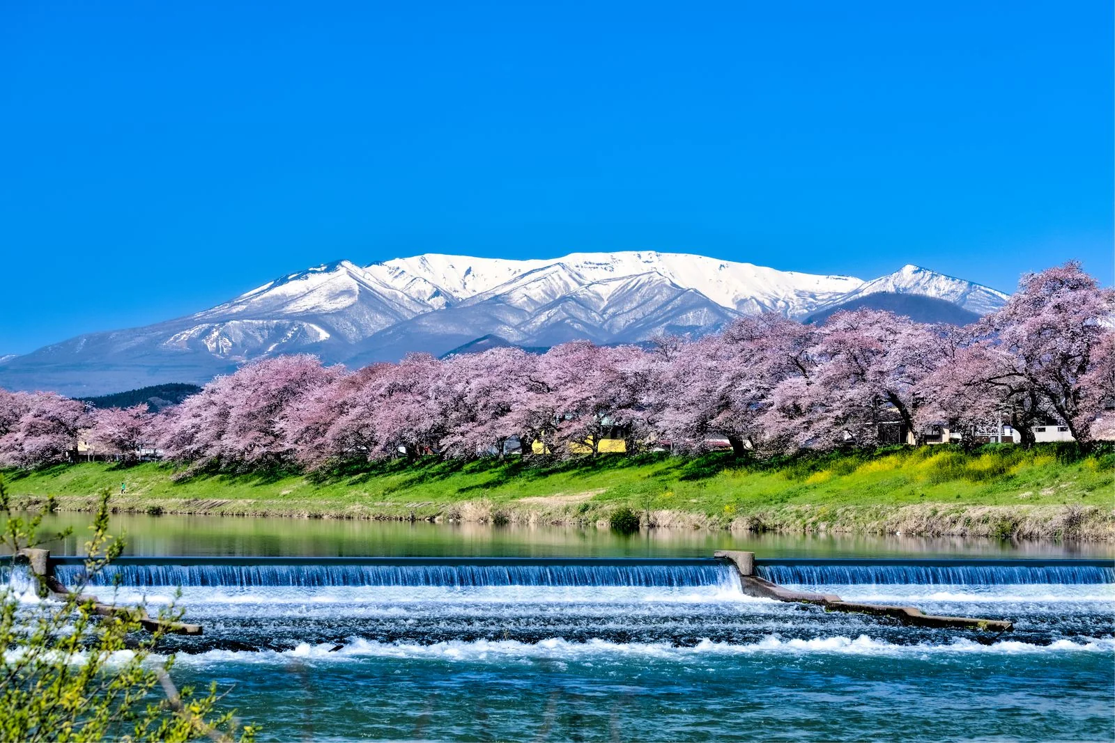
Rather than filling the frame with one blossom, keep the blue of the Shiroishi River and the Zao ridge in shot — that is what reads as Hitome Senbonzakura. Adding one horizontal line — a bridge, a weir, a train — also works well.
The rows run for about 8 km, so you do not have to walk all of it. Match the plan to your time, stamina and company: there is a standard half-day and full-day route plus three purpose-built plans for families, photography and low stamina.
About 1.5 hours walking + 1.5 hours of rest and photography
Up onto the levee from the station, a there-and-back along the riverside rows — the least demanding way to build the visit.
Timing swings widely with how often you stop to photograph. In the morning the light is low, the crowds are thinner, and the band of trees is easiest to frame.
About 3 hours walking + 3 hours of rest, food and photography
Combines the rows on the Shiroishi levee with the hill at Funaoka Castle Park across the river, so you enjoy both the level view and the view from above.
On peak weekends the stations, toilets and restaurants are busy. Shift your lunch hour, and bring warm layers if you are staying for the evening illumination (roughly 18:00–22:00).
With infants, a short stretch near the station plus a park is the least tiring combination.
Drones need permission under aviation law and from the river administrator and municipality. Do not take off from private land.
Steps, level changes and unsurfaced sections do remain. Accessible toilets vary by facility, so checking in advance is recommended.
Roads around here clog during peak bloom. The JR Tohoku Main Line lets you skip the queue for parking and step straight onto the riverbank from the station.
Both are about a 3-minute walk from the Shiroishi riverbank. Entering at Ogawara and leaving from Funaoka makes a good one-way route.
Roughly 15 minutes from Murata IC, about 20 minutes from Shiroishi IC. Plan for longer than usual during the bloom.
Paid temporary lots are set up in some years during the cherry festival. Location, price and payment methods change, so check that year’s official guidance.
You walk a long way along the river. In spring the temperature drops quickly in the morning, evening and wind, so dress in adjustable layers.
Options are grouped by starting point. Times and fares are estimates only and change with timetable revisions, fare revisions and traffic restrictions. No particular operator is recommended.
Sendai Airport Access Line from Sendai Airport Station to Sendai Station (about 17–25 minutes), then change to the JR Tohoku Main Line for Ogawara or Funaoka (about 30–40 minutes). Allow a little over an hour including the change. Driving from the airport is about 40 km via the Tohoku Expressway, roughly 50–60 minutes.
There is no direct train from the airport, so allow time to change at Sendai. Trains are crowded during the bloom.
Shiroishi-Zao Station is a separate station from Shiroishi on the local line, and the two are some distance apart. Either move over to Shiroishi and take the JR Tohoku Main Line towards Ogawara or Funaoka (one or two stops, about 10 minutes), or take a taxi straight from Shiroishi-Zao.
Taxis keep you waiting on peak weekends. Book in advance, or take the train via Shiroishi for certainty.
Take the JR Tohoku Main Line from Sendai to Ogawara or Funaoka. From either station it is about a 3-minute walk to the levee path, and IC cards are accepted. The subway and city buses do not run directly towards the Shiroishi River, so the JR line is the basic option.
Check the time of the last train first. Extra trains and temporary guidance appear in some bloom seasons.
Off the expressway, the approach is via National Route 4 and prefectural roads. On peak weekends temporary car parks open and traffic restrictions or one-way systems may be in force nearby.
Street parking blocks residential and farm roads — avoid it. Allow extra time for congestion.
There are taxi ranks in front of Ogawara and Funaoka stations. Handy for families, for heavy luggage, and for the trip up to Funaoka Castle Park. Ride-hailing apps work in some areas.
Waiting times are long in peak season and the area around the stations is congested. Secure your return journey in advance.
The community buses and demand-responsive transport of both towns differ by route in coverage, operating days and booking method. Bicycles are sometimes lent out at tourist information desks (check whether the scheme is running).
Services are infrequent. Check the timetable first and confirm current details at the tourist information desk or your accommodation.
Times, fares and service patterns are estimates as of September 2026 and change with timetable revisions, fare revisions and road restrictions. Check the official information of the railway operators, the airport and both towns before you travel. No particular operator or mode of transport is recommended.
Hitome Senbonzakura is at 12 Funaoka, Shibata, Shibata District, Miyagi 989-1603. From either JR Ogawara or Funaoka Station it is about a 3-minute walk up onto the levee. Use the map below to work out your route from where you are now.
For the latest bloom status, festival details and traffic restrictions, see the official municipal pages below.
All external links point to official or municipal pages. Their contents may change.
When visiting Hitome Senbonzakura, it is easy to walk on to nearby historic sites and viewpoints — Funaoka Castle Park, Shibata Sen-O-bashi and the Nirugami weir — and each combination changes how the landscape reads. On a short day, add just one.
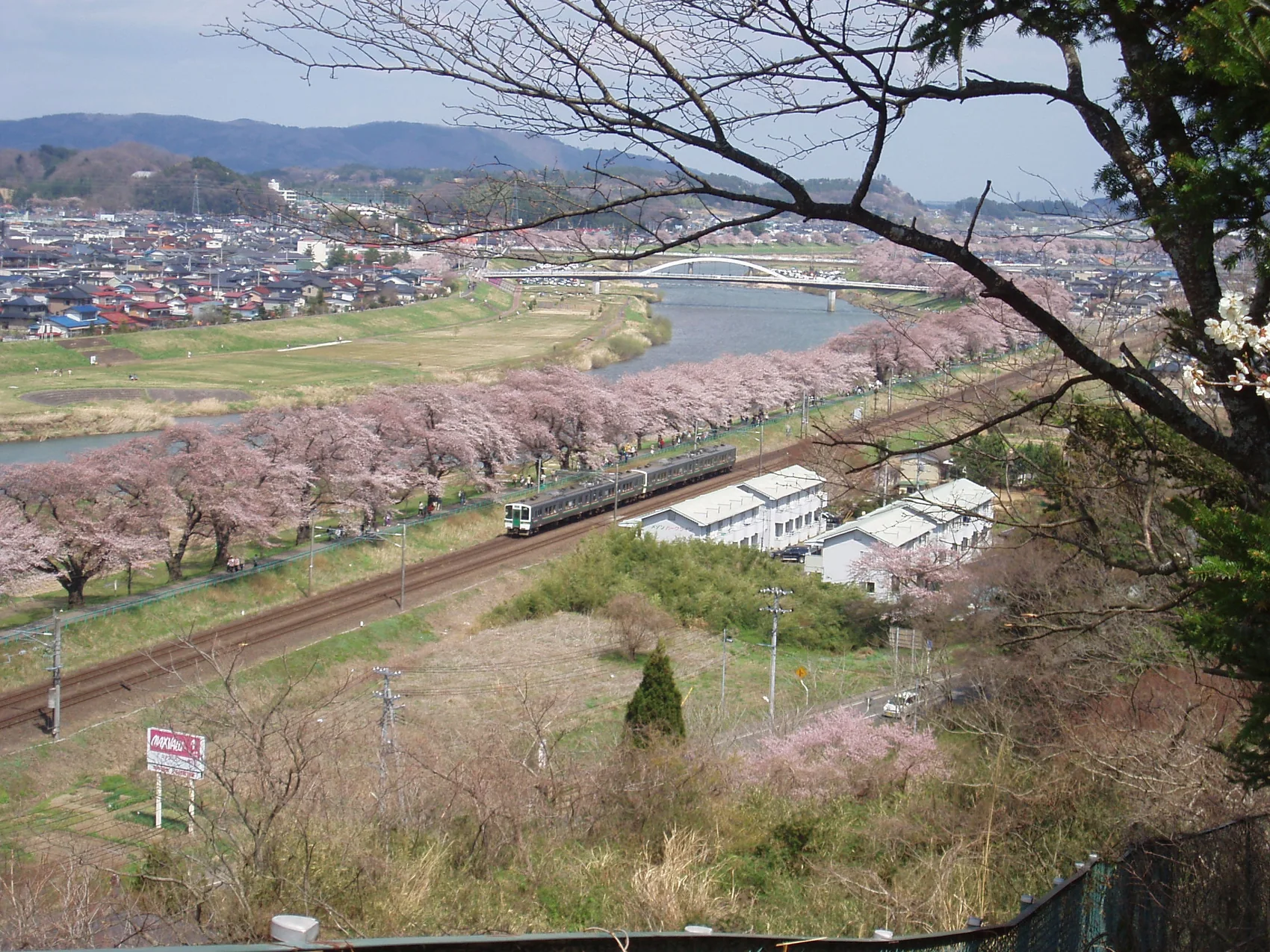
Look down on the cherry band from the hill. Climbing up after walking the riverbank makes the meaning of “a thousand trees at a glance” much easier to grasp.
About a 15-minute walk from Funaoka Station. From the bridge you can frame the cherry rows and a train together.
About a 20-minute walk from Ogawara Station. A viewpoint where flowing water, blossom and the Zao range fit into one composition.
As a non-commercial guide we do not recommend individual shops; this is a list of types only. Opening hours, closing days and what is served change, so check locally.
Scattered around both stations. A hot bowl is a good way to warm up on a cold day.
The option when you want a proper meal. Shifting your timing helps during peak bloom.
Good for a rest after walking. Some offer takeaway.
Useful for takeaway snacks or a light bite on the levee.
On busy days, buying first and eating on a bench or in a park works well.
For seasonal vegetables and local products — and a toilet break.
True to its name, the thing that matters most here is the view of a thousand cherry trees at a single glance from the levee. The rows standing today did not appear naturally: they grew out of donated saplings, planting, and more than a century of care by local people.
In 1923 (Taisho 12) a local businessman, Kaijiro Takayama, donated more than a thousand Somei-Yoshino saplings — worth about four thousand yen at the time — to the town and planted them along the Shiroishi levee himself, which is held to be the origin of the rows. At the foot of the Ogawara bridge stands the “Ojuhi” monument recording his contribution, with the story carved into its inscription.
Preventive work against witches’ broom by Shibata Agriculture and Forestry High School has continued every year since the early Showa period and was recognised by the Japan Cherry Blossom Association in 1970. The Ogawara Lions Club has replanted every year since its founding in 1979, and in 1993 a 1.6 km section was rebuilt under the “cherry embankment model project”.
Stand on the levee and a band of pale blossom runs far along both banks. The phrase “a thousand trees at a glance” became the name outright — a name born from the view itself. The rows now continue for roughly 8 km.
In March 1990 the Japan Cherry Blossom Association selected it as one of the “100 best cherry-blossom sites”. It was also named among Miyagi’s 100 new tourist sites in 1987, the 100 new Japanese street-tree scenes in 1994, and the 100 best promenades in 2002.
Across the river, Funaoka Castle Park is the site of Funaoka Castle, associated with the Shibata and Harada clans. Somei-Yoshino were planted from the Meiji era onward, and today it is known for roughly a thousand cherry trees, the slope car (305 m one way) and a Peace Kannon statue about 24 m high. An observation deck inside the park references Shugoro Yamamoto’s novel Momi no Ki wa Nokotta, marking the site as the home of Harada Kai, known from the Date disturbance.
The planting passed its centenary in 2023. Cherry trees have a lifespan, and the rows are kept alive through continued replanting and renewal. Visitors not damaging the trees and respecting local life is the condition for the next hundred years.
Sources: Ogawara tourism site, “The town’s symbol Hitome Senbonzakura” (www.town.ogawara.miyagi.jp); the official Hitome Senbonzakura regional tourism site (hitome-senbonzakura.jp); Ogawara Tourism Association, “One of the 100 cherry sites” (www.oogawara.or.jp).
The volcanic shape of the Zao range, the river-built form of the Shiroishi, the cloned nature of Somei-Yoshino, and nearly a hundred years of care. Only all four together produce a band you can read as “a thousand at a glance”. The notes below break it down so you can follow the reasons as you walk.
The Shiroishi is a class-A river flowing through southern Miyagi, a tributary of the Abukuma system. It rises on the southern slopes of the Zao range near the Yamagata border and joins the Abukuma around Shibata. The levee is built on the broad valley floor the river carved, and its crest serves directly as the path — which is why the rows run unbroken.
The Zao range to the west is a group of volcanoes active since the Pleistocene. Soils derived from volcanic ejecta drain well, which suits cherries. Snow lingers on the peaks into early spring, producing a three-layer view: white ridge, blue sky, pale band of blossom.
The rows are mainly Somei-Yoshino, with about ten per cent mountain cherry (according to the Ogawara Tourism Association). Somei-Yoshino is a cultivar raised from Oshima and Edo-higan cherry, and has been propagated by grafting and cuttings.
Somei-Yoshino are genetically almost identical clones. Buds form the previous summer, winter chill breaks dormancy, and accumulated warmth in spring drives flowering — so trees in the same area open together within days and fall together. That is what turns a whole levee into one band.
One common cherry disease is witches’ broom, which swells branches into broom-like tufts. The rows did not appear naturally: they have been kept through steady work — cutting out infected branches, replanting. When trees are replaced, choosing the variety and managing vigour are essential.
Spring brings bloom and the small birds working it; summer, fresh green and a breeze off the river; autumn, cherry colour and leaf fall; winter, swans arriving from the north and snow on Zao. The same levee shows a completely different face each season.
As a non-commercial guide we name no individual shop or operator; facilities are listed only by type. They are grouped under eight headings: toilets, food, shopping, parking, fuel and EV charging, lodging, safety equipment, and accessible routes.
Accessible cubicles and changing tables vary by facility. Queues build during peak bloom, so it is worth going as soon as you reach the station.
This is a non-commercial guide, so no individual shop is recommended. When it is busy, takeaway and off-peak meal times work well.
Drinks, snacks, rain gear and power banks can be restocked around the stations. Some stalls take cash only, so carry a little.
Street parking blocks residential roads and farm access — please avoid it. Restrictions and prices change yearly, so follow the on-site signage.
Petrol stations may keep shorter hours. Confirm the connector standard (CHAdeMO and others) and output in advance, and plan charging before you arrive.
Lodging near here fills early on peak weekends. Searching Sendai city and the Shiroishi area as well widens the choice. Book through official booking desks or hotel booking sites.
If you feel unwell or are injured, ask station staff or the tourist information desk. Ambulance and fire: 119; police: 110.
Unsurfaced sections, steps and level changes remain on the levee. Turn back within a comfortable distance and avoid routes that require going down to the riverbed.
What is listed here is the type of facility, not a recommendation of any particular operator. Opening hours, prices and equipment change, so follow on-site signage and the official information of each facility.
These rows are public property, and they sit right beside where people live. Protecting the trees, river safety, rubbish, photography and consideration for neighbours — here is specifically what visitors need to respect.
Do not break branches, climb the trunks or compact the soil at the base. Once a tree’s vigour is damaged it takes many years to recover. Even if you see a branch that looks diseased, leave pruning to the managers and report it to the town or the tourism association.
The level can rise quickly after rain. Follow the signage on the riverbed and at the water’s edge, and never go down when the river is high or water is being released. Fishing and collecting plants or animals can involve fishing rights and permits.
Take your hanami rubbish with you and follow local sorting. Clearing up after a picnic included, protecting the local living environment is what hands these rows on to next year.
Use tripods and step stools where they block no one and pack them away when it is crowded. Drones need permission under aviation law and from the river administrator and municipality; do not take off from private land. Be considerate when people feature prominently in a shot.
Below the levee are houses, farmland and private lanes. Do not enter private land, park on the street, idle your engine or raise your voice at night. It is because people live here that this landscape survives.
During the illumination (roughly 18:00–22:00) it is hard to see underfoot. Bring a torch and walk quietly. On peak weekends use public transport, and give way to pushchairs and wheelchairs.
This Hitome Senbonzakura guide is an independent, non-commercial explanatory site. It advertises and recommends no particular operator or shop, and lists facilities only by type. Natural information such as bloom timing, water level, wildlife and service patterns changes year to year, so always check primary sources — Ogawara, Shibata, the tourism associations, the Miyagi tourism federation, the JMA — before visiting.
Walking the Shiroishi levee is free. Seasonal sightseeing boats, the slope car and similar services charge separately. Because prices can change year to year, no fixed amounts are listed here.
Temporary car parks are announced in some peak seasons. They operate differently from normal, so follow on-site signage and that year’s official transport guidance. Avoid parking on the street.
With little time, stay on the riverbank near a station. With two to three hours, walk as far as the Nirugami weir. With half a day, add Funaoka Castle Park and a meal — built up in stages, it never feels forced.
Rating and review count synced from Google Maps user reviews as of September 2026. Copyright in the reviews belongs to their authors and Google Maps.
See all reviews on Google Maps↗The snow-streaked Zao range, cherry rows in full bloom and the blue water of the Shiroishi all came together in one picture — I kept stopping as I walked.
I walked slowly along the river from Ogawara to Funaoka. A cherry tunnel nearly 8 km long looks composed from any point you cut it.
Peak weekends bring plenty of people and cars. Coming by train puts you straight onto the levee from the station, which is far easier in the busy season.
I visited during the petal storm. Blossom drifting on the water has a different appeal from full bloom.
The view of cherries and trains from the hill at Funaoka Castle Park is a highlight. The paths are easy to walk — do wear proper shoes.
The review texts shown are reference excerpts summarising Google Maps user reviews. Please read the originals on Google Maps. Reviews appear on this page as reference only and are not included in structured data (JSON-LD). Ratings were synced in September 2026.
The points worth checking before a spring visit.
Usually between early and mid April, though flowering shifts with that year’s temperatures. Coming from far away, check the official bloom information from Ogawara and Shibata before you set off.
Walking the riverbed and along the levee is free. Sightseeing boats, the slope car and temporary car parks that operate during the cherry festival may charge separately.
Ogawara suits a walk centred on the river and Mount Zao; Funaoka is convenient if you also want Funaoka Castle Park and Shibata Sen-O-bashi. You can also enter at one station and leave from the other.
Yes, but roads around here are congested during peak bloom. Temporary car parks are set up in some festival years, but location, price and operation change, so check the official guidance. In the busy season the JR line is the easier choice.
Allow about two to three hours to enjoy the riverside at an easy pace. Add Funaoka Castle Park, a café and photography and you are looking at half a day.
Yes. The river, the Zao range, the railway and the embankment rows form one landscape, so first opening and petal-storm days each have their own face. After rain or on calm days you can also catch reflections.
You can use station toilets at JR Ogawara and Funaoka, public toilets in nearby parks, convenience stores, and roadside stations or farm shops. Temporary toilets are sometimes installed during the festival. Accessible toilets vary by facility.
Rainy days are quiet, and the colour of wet blossom and the water surface are worth seeing. Watch your footing on slippery unsurfaced sections and do not go down onto the riverbed. In strong wind an umbrella is awkward — a rain jacket is better.
It is about a 3-minute walk from the station to the levee path, and surfaced sections are fairly easy. Unsurfaced sections, steps and level changes do remain, so a short out-and-back is safest. The slope car (305 m one way) avoids the climb to Funaoka Castle Park.
Along with business hotels near the stations there are inns and guesthouses, and hot-spring lodging towards Zao and Togatta. Peak weekends fill early, so including Sendai city or the Shiroishi area widens your options.
Petrol stations along the main roads, expressway service areas and parking areas, and rapid chargers at roadside stations and some public facilities are available. Check the connector standard (CHAdeMO and others), output and opening hours in advance.
Use tripods where they do not block the path and pack them away when it is crowded. Drones may need permission from the river administrator and the municipality as well as under aviation law; avoid taking off from private land. Be considerate when people feature prominently in shots.
On peak weekends it starts filling from about 10 am. Weekdays, or early morning, are easiest for walking and the low light suits photography. The evening illumination window (roughly 18:00–22:00) is another good target.
This site does not publish its own forecast. Early to mid April is the usual guide, shifting with the year’s temperatures. Just before your visit, confirm the latest bloom status and festival details with the official sources of Ogawara, Shibata and the Miyagi tourism federation.
Yes. The JR Tohoku Main Line runs directly from Sendai towards Ogawara and Funaoka, and it is about a 3-minute walk from the station to the levee path. Allow two to three hours for the riverside, or half a day if you add Funaoka Castle Park and a café.
Dogs on a lead are generally welcome on the levee path. Peak weekends can get crowded enough to make passing difficult, so choose quieter hours, clean up after your dog and be considerate. Cafés and indoor facilities set their own rules.
The snow-streaked Zao range lies to the west, upstream along the river. On clear days, especially in the raking light from morning to late afternoon, the ridge is easiest to catch. In spring snowmelt makes the river murky, so aim for a calm early morning if you want reflections.
The rating shown here (4.6 / 5), the review count (1,099) and the review excerpts are synced from Google Maps user reviews as of September 2026. Copyright in the reviews belongs to their authors and Google Maps.
See all reviews on Google Maps↗Bloom timing estimates, the cherry festival and traffic restrictions are compiled from official information published by Ogawara, Shibata, the Ogawara Tourism Association and the Miyagi tourism federation. Always confirm the latest situation on the official pages.
Current conditions and the seven-day forecast are fetched server-side from open weather data (Open-Meteo) and cached for a period. For disaster information, warnings and advisories see the official JMA page↗. Seasonal normals come from the Japan Meteorological Agency’s past weather data search (Sendai, 1991–2020 average).
Photographs on this page come from Wikimedia Commons. See “Photo credits” at the bottom of the page for attributions and licences.
This site is an independent travel guide and is not affiliated with or endorsed by Google or Google Maps. Review texts are not included in structured data (JSON-LD) and appear on the page as reference only.